Cape Town to St Helena

Réunion to Richards Bay, South Africa

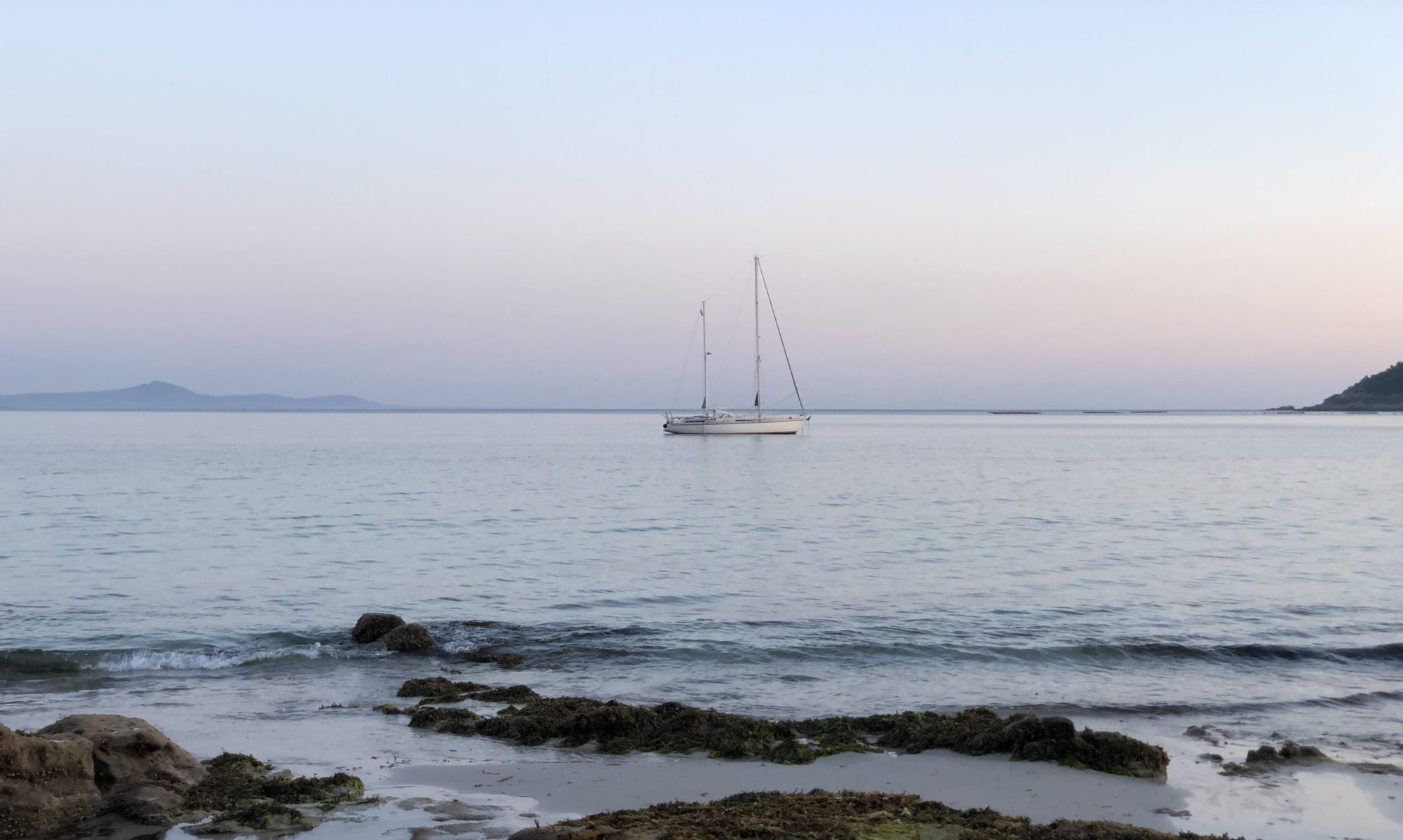
Welcome to join us on our sailing from Réunion to South Africa. The journey of 1428 nm took just over ten days and covered all kinds of weather – from almost mirror-like to gale, rain and thunder to sunny days. The day we left was Arthur’s birthday, and below you can see our first sunset on this trip.

We both enjoy the long passages a lot. Despite that, a route that has never been sailed before entails greater uncertainty, and that was the case this time as well. The ”threat” we knew was that around southern Madagascar it could be windy any way, and then we would have to cross the infamous Aghula stream which runs in a north-south direction. The winds, on the other hand, blow for a couple of days in the north-south (same) direction – which is what we want, but then the wind turns and blows against the current – and that is the dangerous thing – then the waves can be 20 meters high at worst. Nobody wants to end up in that, but predicting it ten days in advance is difficult, so you have to have a backup plan, for example, sailing north near Madagascar. Arthur had seen three high pressures in a row, so we hoped the forces of weather would be with us all the way.
What follows is one or a few pictures from each day. The motive is what surrounds us in the Indian Ocean. I connect with a lot of wisdom – it’s like existence is talking to me and showing me what really matters. Join me and slow down, and you too will see the beauty that surrounds us.
We take turns to watch every night. It’s me, Anna, who has the morning shift. I love watching the sunrise. It takes around an hour and is my sacred time.
The next morning starts much brighter. Suddenly everything feels easier.

After half an hour, we have a completely different scene. The sun looks so small, when in fact it is not.

When I look at my pictures afterwards on the computer, I sometimes zoom in on the mysterious core of the sun.

For me, a passage is very much about being with what is – the waves, the wind. The sunrise is a beautiful reminder that we all are given a new chance.
Every day and in every way it is getting better and better. Émile Cloué.
Day 3. See how the contrasts are enhancing each other.

Day 4. The inherent light and energy are stronger than we might think. This is another example of an image that I edited afterwards. This morning was pretty pale, and I was curious to see how the picture would look with a little more colour. I think this is a perfect reminder of our potential, if we raise our energy, there are more ”colours” in all of us. And there is always light somewhere!

Day 5. This was a day we didn’t go outside at all. It was raining, and later we had lightning behind us. No thunder sounds, only lightning flashes.
Day 6. The sun ALWAYS comes after rain. This day we got some fascinating skies. The two first are from the morning and the third one is just after the sunset.


Day 7. Our new passenger has perfect sea legs. I feel like him (or her) when I cook on the high seas and wish I, like the grasshopper, had more arms and legs.

Out at sea, there is both a lot and a little to look at. Consciously, we choose not to spend time watching movies. We see sailing on the seas as a great opportunity to be with ourselves and the surrounding magnificent existence.
One observation is that all animals and birds in the immediate area seek contact. The dolphins are well known for playing at the bow. We haven’t seen any on this trip but on others. They can come from far away and stay for quite some time. There are coming birds from time to time – and they also take the time to fly around the boat for a while. Often I hear them singing from inside the salon, so I go out and greet them. It is always a great honour if they come down to the boat for a rest.
In all oceans, there are schools of flying fish. Small silvery fish flying just above the surface. Often some of them land on the deck. Since they’ve often dried before we find them, I’m not too sure how I feel about it. We have not been able to see them as food that comes from heaven.
Day 8. Do you see the white dot between the stern stays? It is Venus, the evening star, named after the goddess of love and beauty. After the Moon, Venus is the brightest planet, at its peak in the early evening and morning. Venus is a hot planet, 464°, and is about the same size as Earth, with the same proximity to the Sun.

We are in the short time zone known as the blue hour when these two pictures are taken. Almost an hour long before sunset, but much shorter, around ten minutes, after sunset. I can’t see the blue with my eyes, but the camera detects it easily.

Day 9. Every day brings something different. This morning, this big cloud fascinated me.

After just twenty minutes, the sky and clouds looked completely different.

At 5.42 AM the Sun makes entrance.

And three hours later, everything is pure blue. This blue impression was very common in the Pacific – there it was like this day in and day out. In the Indian Ocean, this is a rare sight. This day we had magical sailing in little wind (12 knots) and no waves. In Sweden, we call it champagne sailing – when there are only small ripples on the surface but still enough wind to sail on – a feeling of euphoria.

Day 9. A new morning – a new day with new opportunities.

For a little while, this sunrise created gold on the waves. It was a magical moment. A wave is like an opportunity – they are around us all the time. We always get many chances. Do we see them? I had to zoom in, then they became even more magnificent and obvious.

In the afternoon, I felt that ”something was in the air”, so I went outside to look. The whole sky was filled with birds. Maybe they are not so visible, but they were many. Usually, it’s only one or two at a time.

I could see the clouds quickly building. We were near the centre of a low pressure. We knew it was out there somewhere. Predict Wind, our weather program has six different models. Four of them proposed a southern route and two a more northerly route. We followed the southern route, but it turned out to be the route right into the low pressure. Not so easy to know what is the best choice every time. In any case, it was beautiful.

After an hour the wind changed, and we had to cruise in the rain with the sea towards us.

Day 10. The moon is so quiet and magical. Suddenly it’s just there. We love to sail with a rising moon.

The light feathers high in the sky.

Day 11. This is the day we enter AFRICA, Richards Bay. It started with a fantastic sunset in the stern.

And it ended in rough seas, waiting for a cargo ship to pass through the entrance channel.

Fortunately, it was very calm in the inner harbour. Below is the Q-doc, where all sailors must first go to get their visa permits. The tide is up to two meters here.


The next day, we went over to the nearby Zululand Yacht Club, which has the nice tradition of celebrating all new arrivals with a bottle of sparkling wine. The flowers are Protea, the national flowers of South Africa. Time to celebrate!
With this ”leg” we also completed the 5664 nautical miles sailing of the Indian Ocean. A trip that took us a total of three months, July to October, from Darwin in northwestern Australia to Richards Bay in eastern South Africa.

Sailing on The Indian Ocean – from Cocos Keeling to Rodrigues


It’s a tough journey, say those we spoke to. We are about to take the leap between Cocos Keeling, Australia’s westernmost island, to Rodrigues, Africa’s easternmost island. A two-week journey of around 2000 nm, right in the middle of the Indian Ocean.
The Indian Ocean looks like a big belly, surrounded by four continents – from Australia in the east, Africa in the west and Asia (Saudi Arabia, India, Indonesia) in the north, all the way down to Antarctica.
One good thing about the Indian Ocean is that there are many small islands to stop at during the long passage. We have already been to Christmas Island , and we have three more to visit before we reach South Africa.
The Indian Ocean is also said to be the windiest sea, in contrast to, for example, the Pacific Ocean, which in Swedish is called the calm sea. Here in the Indian Ocean, this season, constant high-pressure forms that start from Madagascar in the west and go east to Australia. They are the ones that create both the trade winds we love to sail on and long-distance swells – waves that we already knew when we started would be 4–5 meters high.
Decision on Departure
We are already in the best season to sail in these waters, as the prevailing winds are from the east-southeast, giving us wind and waves from behind – a must for sailing, on any sea.
Still, there are differences – it’s windy – more or less. Here at Cocos Keeling, we had a gale last week. No one moved, and the cargo boat that came did not unload because of high waves and swells.
What follows are my daily notes and photos from this journey.
How was it to sail on the Indian Ocean in the high waves and strong wind?
Day 1, Monday 21 August

We set off early in the morning when it was still high tide, the first calm day after the gale. So do even Rondo and Alado, the other two yachts that arrived around the same time as us. The anchor is filled with coral sand, which easily slides off. We announce our departure to the Cocos police, and on the way out we notice that the cargo ship had begun to unload. We see flocks of birds flying close above the water – a sure sign of fish below.

Just after an hour, we set a direct course towards Rodrigues. The wind increases, so we take an early reef in the Genoa and before night falls we take a second reef when the wind increases to 25 knots. Over 20 knots are a lot of wind, and safety is always paramount. We rest as much as we can, and we call our mothers when it’s still calm.
After the sun sets, we encounter two cargo ships, both on a collision course. After some talk on the VHF, they adjusted their course. We have no idea if there will be many boats on this trade, or not. Regardless, every meeting requires careful monitoring, especially at night.
An early warning
An important rule is to always keep our hand on something because we never know when a big wave might cause an overhaul. Cooking is therefore a challenge and a balancing act. We got an early warning today when captain fell to the floor when a big wave suddenly rocked the boat. Luckily, he managed with just bruises and a sore back and elbow. We take out the safety harness for the stove for the first time.
Day 2, Tuesday 22 August

We sail towards the sunset in the west, so the sunrise is always in the stern. On the second day we only see the sun in the morning and in the evening, in between it is a grey day. It feels calmer, we are getting used to 20 knots. The wind continues to increase. We make good speed, 174 nm (nautical miles), on the first day.
We look ahead at the weather forecast and see more wind and high waves for the coming weekend. What is it like to sail in five-meter waves? I’ve never done that before. Is it dangerous? How can we prepare? We cook some food in our pressure cooker and set up the back cover in the cockpit.

Day 3, Wednesday 23 August

The wind is now down to 13 knots, we did 160 nm on the last day. We have already completed 25% of the journey – something to celebrate! There aren’t many boats out here – just two cargo ships on long distances.

Day 4, Thursday 24 August
We measure how far we have sailed each morning to estimate the arrival time – on the last day we did 165 nm, and the wind was around 15 knots. It’s a grey day, and we know this will be our last slow day. We bake bread and a yummy lamb stew. In the evening the wind starts to turn – for seven hours there is no wind at all, so we drive through until the wind increases rapidly at midnight, and soon we take in two reefs again. On the weather maps, we can see that we are on the edge of a high-pressure area.

Day 5, Friday 25 August
We are now in the area of relentless and unstoppable trade winds. It goes fast – we make eight knots, even though we have four reefs taken. We lie on the sofas. What’s a bit strange is that I decided to start writing my story with flowers. It’s a perfect distraction, and it makes me happy to go through all my photos with flowers and write about my love for them.
Day 6, Saturday, 26 August – Halfway!

It still goes fast, the gusts are up to 30, so we keep the four reefs. The day’s distance reaches its peak at 183 nm. We’re halfway there! It is a mentally important milestone. It is not closer to turning around if something happens. You just know you have to keep going. You also know that the boat can handle open seas and wind.
This day we realized something else, namely that our gas probably won’t last the whole trip. We have two bottles in a cupboard in the stern stowed away, so we just need to change the fittings, usually very easy. On the open sea with waves washing over, even that is too risky. Balancing at the back of the deck, and picking up a few things to reach the locker, is just something we don’t want to do. We don’t go outside the cockpit at all. So, this was a lesson learned. In the meantime, we’re keeping our fingers crossed that it lasts, and we’re discussing our options for various canned and cold food.
Day 7, Sunday, 27 August
The waves get higher and higher, coming from behind and rapidly rolling forward one by one. I force myself to go out and look at them, I know it helps. I see and feel that we are being carried. Very fascinating and astonishing.
Day 8, Monday, 28 August

Today we reach the peak – the waves are 4–5 meters high, and we are still being carried! The difference isn’t that big, we’ve slowly gotten used to the higher levels. The weather is dramatic, with clouds shifting rapidly and suddenly picking up the wind and pouring down rain. The captain feels the contradictory movements in the boat – there is the wind and waves coming from behind (east), but also swell, bigger waves coming from far south.

Day 9, Tuesday 29 August

Finally, it turns – the wind drops, and we take out two reefs and now have ”only” two reefs furled. A nice sign is a bird and a flat rainbow, something I’ve never seen before.

Day 10, Wednesday, 30 August
It’s a great feeling to sail towards the moon. This is early in the morning when it’s on its way down.

Today it is even nicer, the wind blows 15 knots and fills our now-released Genoa perfectly. I take care of sunbathing, which rarely happens. And to my delight, a double rainbow lights up in the afternoon. Captain and I have a good sharing, or perhaps more accurately debriefing time, with each other.


The moon goes up before the sun goes down!

Day 11, Thursday, 31 August

We get a beautiful sunrise and later a dramatic sunset. It’s a full moon tonight, so I am not surprised.


Captain treats us with homemade pan bread made from tapioca flour. Luckily for us, the gas lasted until this day, and we had no problem at all changing to a new bottle.
We are going slower now, the wind is down to 13 knots which means that the feeling of swell increases, as the wind does not match the still quite high waves.
Every rainbow is worth a picture as it is pure magic.

We are getting closer to Rodrigues, with only 130 nm to go. In the evening, we start to see other boats on the plotter. At first, it looks like one fishing boat, but the closer we get there are more and more of them, a whole little armada.

Day 12, Friday 1 September

We are happy to arrive in daylight. As usual, we see land from afar. It takes hours and hours to get closer. We thought we should get some lee from the island, but instead, the wind increases the closer we get.

We shall pass through an invisible reef; we just have to trust the plotter. Captain searches for a transit line without success. After a long while, I see a bright white light on a house in the direction we are moving. It must be for us seafarers. We proceed slowly and when we are inside the reef we take down our Genoa pole before turning 90° to the anchorage. There is a large cargo ship at the dock and a single sailboat. We anchor next to him, and soon we have two people from the border police and one from the health administration on board. You should have seen the eyes of the police officer in charge – so loving. Imagine all the police officers in such strong contact with their hearts!
After the quick meeting, we had to take the dinghy ashore to face customs and immigration, fill out many more papers and show passports. Before we were ready with everything, the sun was almost gone. Tired and satisfied, we celebrated this journey, 2013 nautical miles in 12 days and six hours, as successfully completed.

Saturday, 2 September, in Mathurin, Rodrigues

We are very happy that we managed to arrive in time for the Saturday market. Once a week the local farmers turn up at the marketplace and as we haven’t had a market since Darwin six weeks ago, we were eager to see what they could offer us. We were pleasantly surprised, everything looked very fresh, and the range was wide. We secured eggs and fresh vegetables and went back to the boat to wash, clean and rest.

LESSONS LEARNED
- We manage more than we think.
- It helps to be present, breathing into what is.
- Worrying about the unknown (high waves in this case) is 100% unnecessary and helps nothing.
- It’s wonderful to have a boat that is seaworthy, rainproof and can take the waves smoothly.
- Tasty food is a nice treat, preferably pre-cooked.
- There is no need to be seasick – preventive pills exist and they work.
- Take it easy and relax a lot.
- Unexpected creativity can come even under those circumstances.
- The ocean carries us, again!
NEXT STEP
Our next passage will be from Reunion to Richards Bay, around ten days. Stay tuned.
Cocos Keeling

Another remote island, an atoll consisting of 27 mini-islands in the middle of nowhere, specifically in the Indian Ocean, three and a half days sailing from Christmas Island.

TO MAKE A LANDFALL
We want to arrive in daylight, so we can anchor safely on sand and not on one of the many coral heads. We have adjusted the sails, so we go slower. It’s early when we cross the sea border of Cocos, 12 nautical miles out. We have read that Border Force opens at 8am, so we keep approaching. The police call us at 7.30 on the VHF. They want to check the formalities: number of people on board, nationality, any animals or weapons on board and where we are from.
Even in daylight, approaching the anchorage is quite scary. There is a red and a green stick that marks the entrance, but there is also another stick that confuses us, and it looks dark everywhere, equal to coral, in the otherwise turquoise water. We turn back and call the police and ask. Better to appear stupid than a besserwisser going aground. The boat that came after us made almost the same mistake before we pointed him in the right direction. And just now another ship comes in, also without reading the entrance sticks correctly. This time the police spotted them and let them stay out there – I guess, until they have done the clear-in-procedure.
We pass the dark part and anchor on white sand. Many reef sharks circle around to say hello. And after a short while the police arrive. Very easy and friendly check-in procedure.

DIRECTION ISLAND
The only place for foreign boats to anchor is at the northern corner of Direction Island. From the boat we see a lot of coconut palms, a small jetty and some huts by the beach. We also see beautiful little white terns flying in pairs, which I later read are called love birds.

THE FIRST DISCOVERY
History says that this island was discovered by Captain William Keeling in 1609. Much later, in 1825, the French ship, Mauritius, made another attempt but was wrecked. Charles Darwin on HMS Beagle visited the island in 1836.
Residence at Cocos Keeling began in 1826 when the Clunies-Ross family started to export copra – whole coconuts were exported to Singapore and Mauritius, and coconut oil to Java and Great Britain. Much of the islands were cleared to make way for endless rows of palm trees, and labour was imported from Malaysia. The coconut export is history now – the palm trees remain as a living memory. The island was declared British in 1857. Since 1955 they belong to Australia, self-governing at the local level.

THE HISTORY OF THE PARADISE
So here we are in what feels like a paradise. When we go ashore, we get to know that this was a strategic place in the First and Second World Wars. The short walk around the island tells the story.
In the early 20th century, the world started to connect to each other through telegraphs. Cables got laid out on the ocean floor, with cable stations at strategic places. From the UK to Perth in Australia, via Durban, Mauritius, Rodrigues and here at Cocos Keeling (1901). Another link went up to Jakarta and later Singapore. This cable station was destroyed in 1914 by the Germans during the First World War. It was rebuilt and finally closed in 1966 when a new, more direct cable replaced the old one.
The Cocos Keeling was reached by air for the first time in 1939 during the Second World War. A military airbase was established on West Island, in 1945.
DEVELOPMENT
A new era of communication technology is developing, this time from above. Elon Musk has made satellite communication, Starlink, available for the public.
Cargos comes every sixth week with supplies, and aircraft comes every second week with fresh food. Small ferries make daily tours between Home and West Island.
And some yathies pass by during the trade wind season. We have been three boats here this week, and last night came another two. It’s still remote and strong winds come and go, making it very tough to go anywhere.
The locals also come here on the weekend to have a picnic. We got invited to eat with them. The kids picked small stones of glass to write their names in the sand.

TOURISM
Although a military ship is anchored in the entrance to Cocos Keeling, it looks like tourism is the thing these days. Small boats come from time to time to visit the fine coral beach here at
Direction Island. For the first time we leave an imprint after us.

The main attraction is the Rip – a narrow strait between Direction Island and the next, Home Island – where a strong current makes it possible to float with it and watch all the fish.

As on Christmas Island, we see many small crabs; hermit crabs that protect themselves in borrowed empty mollusc shells, and so-called ghost crabs that dig holes in the sand. They love coconuts, and people who come here leave open nuts for them to eat.
Another special thing is here in abundance – it is sea cucumbers, an expensive delicacy if you ask the Chinese people. They are the size of large green cucumbers, but they are alive and black and live on the sandy seabed. We tried them – taste like squid.
Locals use a machete to open coconuts. Westerners drill and then use an axe. And here on the boat, captain also uses a drill and then a Japanese knife. The nut is hard! Imagine the power of that little shot to get through the shell.


Christmas Island

In the light of the full moon, we round the northern tip of Christmas Island, a small island in the Indian Ocean, about ten days’ sail from Darwin, Australia. Looking for a mooring, we see lots of flying fish in the light of the flashlight. We also see a huge jetty and some large dark buildings. Flying Fish Cove (the name of the anchorage and bay) is open to the sea, but the high mountain gives sea lee, and the 20-knot trade wind feels calmer here. We catch the third buoy, the one farthest from the jetty, but only two boat lengths to the rocks where the waves loudly announce themselves, along with the many birds that seem to be living on the tree-clad rock wall just behind us. There are two more boats here, from the USA and France, and later we learn that we are the seventh yacht to visit this season (end of July 2023).
Here I share my main impressions of this remote and unique island.

THE BIRDS
The first impression of Christmas Island in daylight is all the birds. The mountain next door is filled with birds in the trees. We learn that many species only live here, and up the hill, there is a bird feeder for the Boobies, who don’t make it on their own on the first try.

THE UNDERWATER WORLD
Looking down into the turquoise water, I see many small aquarium-like black fish swimming around the boat. They hang around us all week. When we later snorkel, we see many more beautiful fishes and live corals. Anchoring is prohibited, and they have nine solid moorings (10AUD/night or 50/week) and some huge ones for larger vessels. The local fishing regulations state that we can only pick four lobsters per day!

PHOSPHATE
The third impression is the large jetty, yellow buildings and cranes on the other side of the bay. It is phosphate mining that takes place – the main reason why this island is inhabited. British sailors found this mineral in the late 1890s and claimed the right to the island. (Since 1958, however, it belongs to Australia.) People from China, Malaysia and India came to work in the mining operations. A Silver City with aluminium houses was built for the workers, and they have a huge hardware store with the saying – what’s not sold here, you don’t need.
THE PEOPLE
Of course, there are nice people here too. It started with the super easy and pleasant meetings with the Bio-clearance check and Custom, who took their time on a Sunday. My biggest concern, about having fresh food and eggs on board, wasn’t even a question for them.
There is a shortage of cars. We were too late to book, but luckily it worked out anyway. In the hunt for a car, we were invited to dinner by Nigel and Ruby at Ocean View Apartments. Every Monday they invite those who live in their apartments, friends, neighbours, and sailors to a free dinner. There we met Neesha, a teacher on the island, who offered to show us around!
About 2000 people live on the island, 60% of them from China, the rest from Malaysia, India and Australia. They are said to live in harmony with each other. Well-dressed Muslims with covered hair, living side by side with young people in shorts and tank tops or dressed as mermaids!

THE BLUE HOUSE
As we go ashore, an ultramarine blue apartment building stands out. The Malaysians live here, we learn. They are the ones who go to the mosque nearby, to pray five times a day. My eyes catch the different sofas outside each entrance.


THE CRABS
The big thing on this island is the crabs. There are millions of them, twenty different species that live mostly on land, and some only on this island. Once a year they go down to the sea – at the end of October when the rains come – to mate and lay eggs.
The crabs do a great job – they clean up and keep the rainforest clean and open by eating fallen leaves, seeds, fruit and grazing on new plants.
They also maintain an open and clear understory, aerate the soil and recycle nutrients that help plants grow. 63% of Christmas Island is a national park on ancient volcanoes and limestone, so they have a huge area to look after.
Now, during the dry season (May to October), the crabs hide in the shade and their holes in the ground. Now and then they come out to dehydrate in water. Below you see Red, blue and robber crabs.


The migration procedure begins with the male crabs going down to the sea (taking two weeks) and making a burrow where they mate with the females. Then the males go back up to the forest and the female crabs incubate the eggs (12–13 days), then spawn before dawn during the last quarter of the moon – after this, the females also return.
The eggs hatch immediately on contact with water, and in 30 days larvae develop into megalops. They make it to the beach and transform into crabs that live on the shore for six weeks before returning to the first forest plateau. It takes four years before they become adults.

During this time, a total of two months, the roads are full of crabs. Roads are closed and on the ones that have to be kept open, people use scrapers to get around. They have built low fences on the sides of the roads, to direct the crabs to pass beside the road and through tunnels, and in one place over a bridge.
The good thing about missing this spectacular migration is that the roads are open, and we can see around the island.

THE BLOWHOLES
Another very spectacular phenomenon can be found here, and that is the so-called blow holes. Water shoots up from the holes in the limestone, makes a loud noise and splashes us wet. Nature has so many wonders!

FOOD, ALCOHOL AND DIESEL
We had heard that the food supply comes to the island every other Friday and that the fresh vegetables only last a few days. It wasn’t too bad, even after a week they had plenty of onions, potatoes, apples, carrots and some cabbage. A lot of cans and frozen food were available. The prices were higher, but on the other hand, the alcohol was duty-free and offered a huge variety we have not seen since in Europe.
Diesel was only available in jerry cans at the petrol station for AUD 2.90/litre when we were there. 30% more expensive compared to Australia (where we got it duty-free on departure), but in a remote location like this still good.
THE BEACHES
One last thing from this island to mention is all the beautiful beaches. As sailors, we get plenty of sun and water, so we skipped this, also because the beach at Flying Fish Cove was great and offered nice snorkelling. At cycling distance, we instead found The Grotto – a cave with sweet water at a perfectly cooling temperature.
The last picture shows our magnificent night view from the anchor.

On the way back to Europe

Hi, we are now on the way back to Europe. In some days we will leave Darwin for the Indian Ocean and some of its islands. We will take the southern route to South Africa and then up to the Caribbean, Bermuda and the Azores.
Auckland!

Finally, we are in Auckland with Vista! This was our goal when we left Stockholm. At that point, we had no idea how hard it should be to come here. First, the whole pandemi reduced the numbers of boats that got visas to come here – only for one reason – refit & repair. Secondly, there are very hard to get a berth here, as it is so crowded all over – even if there are many and big marinas around the coastline. They even stack their motorboats on top of each other! That ”room” is also the entrance to the marina.
We are in Oram’s marina, right in the middle of the city. It is so cool! The big grey boat Dapple is just a toyboat – having a subamrine and pressurechamber – amongst a lot more. So we are a mini-boat in this marina. We anyway get a great help of many skilled craftsmen that are having their businesses close by.


We were very lucky to have dolphins joining us on the way here!

La Luna, The Moon 2019-2020
This is my tribute to the Moon. And to the women group Luna that I participated in with big gratitude. I am born and have lived most of my life in the beautiful capital of Sweden, Stockholm. Mostly I never saw the moon. When we started to sail I saw her always. Here will follow my favourite pictures of the moon during our sailing from Stockholm end of May 2019 to New Zealand December 2020.


8 December we reached Opua after 21 days at sea.

